
Weather today was about 80. It was hot and sunny. Just as we returned to the RV the winds that were forecasted arrived and really got strong - still are now at 7:30 pm. Gusting 40-50 mph! Could be an issue leaving here tomorrow. We'll see. We had to pack everything up to keep it from blowing away!
I'll start here with pictures from Monday and our Jacob Lake drive, then finish up with pictures of today's hike.
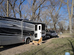
Just a pic of RV as we left for our drive

Roadside motor lodge/inn just West of Marble Canyon (Lee's Ferry) that blends in with the surroundings so well you can only see the doors & windows unless you look close

The Vermillion Cliffs

That's our destination in the background - the North Rim of the Grand Canyon. We were sure we would never get to the Rim as the road is closed in the winter (you'll see why below) - but we tried.

More Vermillion Cliffs

My little camera just doesn't show how vast this landscape is here in front of us. We see canyons, desert, high plateau's, towering cliffs, and snow capped mountains all in one scene. Our pictures only give the pieces of the whole puzzle

Snow covered sign at Jacob Lake. If we stay on highway 89A we would end up back in Zion. Turning here, if we could, would take us to the North Rim via hwy 67.

The Visitors Center

The Visitor

Pretty high snow piles still have a lot of melting to do

The girls had fun

Hwy 67 going to the North Rim - about 50 miles "on down the road"

View of RV as we returned - the RV is in the spotlight so many times just because it really gives one a feel for where we are at. It's just so impressive to see the "little" RV sitting out here in such a remote place

Looking upriver with the Lee's Ferry launch site on the Left. Took the dogs here to have a bath


Ellen forgot to tell me to "suck it-in", but really that's just the wind billowing my t-shirt

Going my way?

Beautiful sunset warning us of bad weather to come


Moon Rise over Lee's Ferry

And Pictures from today's hike - not a lot of comment - just pictures of where we were. As I said earlier we started at a parking lot just off the road. Up the canyon goes into Glen Canyon NRA, down goes into Grand Canyon NP. We went down because we knew we would end up on the banks of the Colorado River where the wash entered


Big flash floods do most of the "heavy lifting" and are very rare - but here you can see the size of the boulders that can be moved.

No maintained trail here - you find your own way down and back up

The canyon gets deeper as it gets closer to the river - but not always this wide.

Made it to the river


All these rocks came from up the canyon. It takes a rare flood to wash them down to the river, but the do eventually get here

River level view back up the canyon we just came down


wild flowers blooming in the canyon

Beautiful pictures! Oh, and I love your definition of "exposure" - LMAO! That about sums it up, eh?! - BFM Mandy
ReplyDelete